")
IN PURACE NATIONAL PARK, COLOMBIA

Project sponsored by Simbiosis Activa and Samanea foundation
These Eco-Christmas cards and bookmarks are available in our ECOSHOP
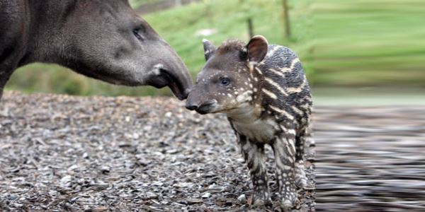
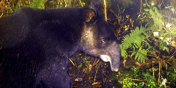
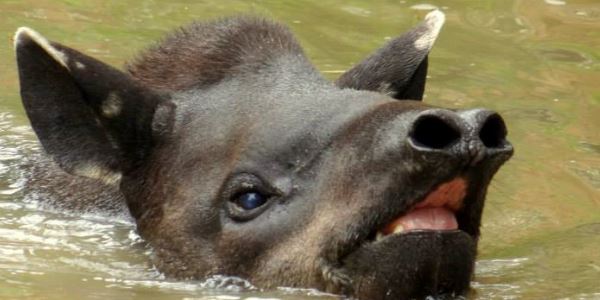
The mountain tapir is restricted to the northern Andean mountains between Peru and Colombia. Although the species has been reported in several sites of the Puracé National Park, no population-spatial estimation of any kind had been made. We sought to determinate the relative abundance of the species by camera trapping approach. We deployed 12 cameras in northern and southern sites of the protected area, in a simple grid arrangement during seven months. A total of 57 photographs of the species were obtained and a relative abundance of 37 tapirs / 100 cameras-night. Three tapirs were identified individually from the records in an area of 3.5 km2 which extrapolated to the area of the Purace Park gave us a basic estimation of population size. Other recorded wildlife was the cougar, spectacled bear, mountain paca, little red brocket, mountain coati, tapeti and tigrillo. We conclude that the protected area is an important habitat for the mountain tapir and other Andean wildlife and we strongly recommend its research and protection.
An educational strategy towards the awareness of the species and its habitat was developed with key actors as the Puracé Indigenous council’s group of guides, students from the settlement school and the park rangers, who were provided with education tools and training for their own work.

Eco-Christmas cards for the Tapir Mountain preservation – Zurich- Switzerland 2013
This project was done for the research and preservation of mountain tapir (Tapirus Pinchaque),
Christmas cards were sold in Zurich Switzerland and with the money collected we buyed equipment necessary for field work (knives multipurpose). For this project it was also required flashlights, sleeping bags, tents and backpacks, money, knowledge, time, volunteer work field among others.
These Eco-Christmas cards and bookmarks are available in our ECOSHOP
Persons who have contributed:
Josef Meile, Lucia Diaz, Ruth Rizzi, Colombia Linda / Café 3, Cristina, Teléfono de la esperanza ONG, Nubia, Martha Reyes, Brasil Afro woche, Brindis Expo 2013, Cristina, Hispano hablantes en Zürich, Venezuela, Switzerland, Targo Bank.
Simbiosis Activa and fundación Samanea we are grateful
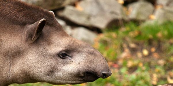
Introduction Mountain tapir (Roulin 1829) is one of the four species that represents the Tapiridae family in the world.
It is distributed in the Ecuadorian, Peruvian and Colombian Andes (Lizcano et al. 2006) and is threatened by the advance of agricultural frontier, poaching and illegal trade of its body parts (Downer 2003).
It is currently classified as an endangered species by IUCN red list (Lizcano et al. 2006), and for this reason the gathering of information contributing to the management of its populations is essential.
In Colombia there are studies that estimate the density of 1 individual per 400 ha, based on the estimate obtained during the same year in Ecuador by a radio- telemetry survey (Downer 1996 b) (Acosta et al. 1996). In later survey, a density of 551ha per individual was estimated through footprint measurements (Lizcano & Cavelier 2000b). However, there are remaining gaps regarding the population status of the species, which hinder to make decisions for its conservation (Lizcano et al. 2005; Lizcano et al. 2006). Currently there are action plans about the species in Colombia (Lizcano et al. 2005, Montenegro 2005) that gave us guidelines and research priorities to address this survey.
Some studies have been developed in the Puracé National Park to contribute to the knowledge on the biology of the mountain tapir. In the year 2005 the Cali Zoological Foundation (FZC) and the Cauca Regional Corporation (CRC) initiated a mountain tapir conservation project in the north of the protected area and in the central zone and its surrounding buffer-zone (Sandoval 2005). Within the framework of this project, Sanchez (2006) identified the vegetation present in spots used by the tapir and cattle incidence in the buffer zone of the protected area. In the same year, Acosta and Ramírez (2006) deployed circular plots and transects in places where they found tapir traces, identifying vegetation present at these plots. Diaz (2008) identified the plants consumed by the mountain tapir in a village near to park and Abud (2010) did the same inside the protected area, but also described the high Andean forest vegetation used by the species. Additionally, since 2007 the park ranger team gathers monthly tapir information in permanent plots and salt licks (Amaya et al. 2007).
The tapir project was an initiative of a local group of biology students interested in contributing to the knowledge about the mountain tapir, thanks to the development of two investigations between the years 2005 to 2010 in the protected area (Sanchez 2005, Abud 2010). We planned this survey through camera-trapping approach for contribute to population parameters and park management.

Location of Purace National Park in Colombia and Southamerica. The right box shows the Mountain tapir range {orange) in the Northern Andes of Southamerica (From IUCN Red List). The middle box shows the National Parks of Colombia delimited by green lines and the study area with red fill. The left map shows in red the two sampling grids in south {Cusiyaco) and north {San Juan) of the park
Objectives
Main Aim
To generate information on the mountain tapir population size and to make a record of the fauna associated to its habitat in the north and south of the Puracé National Park. Alongside we strengthened the social actors’ awareness and assessment of mountain tapir and its habitat through workshops and delivering of educational tools.
Specific objectives
– To estimate the relative abundance of the mountain tapir in Puracé National Park.
– To identify the number of tapirs photographed.
– To record the hours with visitation of tapirs in the camera-trapping stations.
– To record the wildlife associated to mountain tapir habitat that has been captured by camera-traps.
– To develop a strategy towards the awareness of the species and its habitat with key actors of the Puracé National Park.
Changes of the original statement
We added to our original study area, another site in the south of the park to compare the relative abundance estimation. At the same time, we enlarged the sampling effort to cover not only the salt licks, but a representative area taking in account the home range estimations. This allowed us calculate relative abundances indices, a more useful data than frequency of records.
Materials and methods
Study area and deployment of camera-traps
The study was carried out in two sites inside the Puracé National Park. The first one called San Juan Hot Springs (2°20’36”N – 76°18’30.90”W) at the north and the second called the Cusiyaco Lagoon (1°54’52”N 76°37’30.90”W) at the south of the protected area. The features of each zone are detailed in the Appendix B.
Cameras were separated taking into account the half of the mountain tapir home range diameter (minimal estimated by Lizcano & Cavelier 2004b as a 2.5km2 circumference with diameter 1783 meters), then there was an overlap of the areas covered by the cameras inside the home range of an individual, which ensures that tapirs have a detection probability greater than zero. An a posteriori buffer zone was calculated with a fixed width, using the average of the distance among neighbor stations, such as an individual would be re-captured in the nearer stations.
Estimation of the relative abundance of mountain tapir, activity pattern and other wildlife recording
The effective photographs, namely with records of mammals, were classified as independent events following the criteria of O’Brien and colleagues (2003). The first relative abundance index (RAI1) was the total number of nights needed to record the first mountain tapir event, which was then averaged among stations. The second abundance index is the average of independent events recorded in each station during a given sampling effort, in this case during 100 cameras/night (O’brien et al. 2003).
From the predetermined stamp in photographs of camera-tramps, we determine the time of the day and date in which the mountain tapir was recorded. It also allowed recognizing the moon phases in the nocturnal recordings. Besides the mountain tapir, all the photos of wildlife were identified using literature and added to a list.
Identification of tapirs by body features
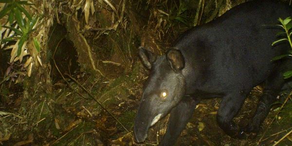
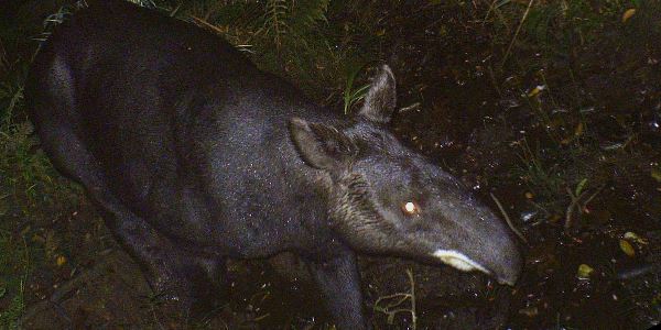
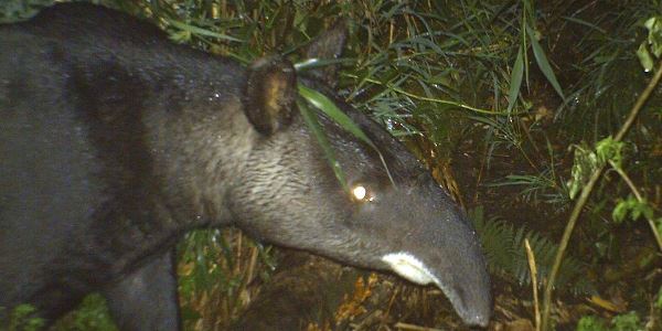
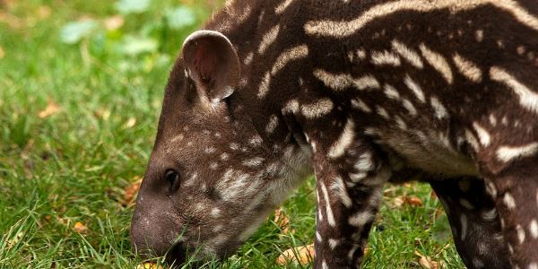
Photographs were clustered according to the left or right animal’s view side. The side with more pictures was selected and then was compared using the physical features of each individual such as the swirls of hair on the snout and the presence or absence of white spots on the top of the ear. Image was de-saturated and features were overexposed as proposed by Traeholt & bin Mohamed (2009). We also determined the sex of two individuals.
Educational Strategy
The team implemented an educational strategy among the Purace municipality social actors, based on communicating and taking actions in the environmental awareness and the reproduction of educational tools (Table 1 Appendix C and D). The actors involved are listed below.
Puracé National Park.
“Andulvio y Vida” indigenous group.
Students of Manuel María Mosquera school (3rd,4th,5th,9 th,10 th,11 th levels).
Results
During the development of the entire study, 57 photographs of the mountain tapir (T. pinchaque), 11 of little red brocket (Mazama rufina), seven of mountain coati (Nassuela olivacea), one of tigrillo (Leopardus tigrinus), four of mountain paca (Cuniculus taczanowskii), four of cougar (Puma concolor), eight of the spectacled bear (Tremarctos ornatus) and two of the tapeti (Sylvilagus brasiliensis) were obtained. The photos and list of animals recorded in every site is showed in the Appendix E.

¨
elative abundance estimation of mountain tapir in Puracé National Park
No photographic records of the mountain tapir were obtained in San Juan Hot Springs, being the reason of why relative abundance couldn’t be estimated for the north of the park. Nevertheless in the Cusiyaco Lagoon, 57 photographs of the tapir were obtained, from which 37 independent records were differentiated.
Using the results of the sampling period, the RAI1 for the mountain tapir was of
12 days/individual ± 18.1 (n = 17), which means that it took an average of 12
days for a mountain tapir to be detected by all the camera traps. The RAI2 was scaled to a sampling effort of 100 cameras/night, yielding a mean value of 3.7
individuals/100-night cameras ± 2.5 (n = 10), which is interpreted as the record of four individuals per 100 cameras per night.
Identification of tapirs by body features
In the Cusiyaco Lagoon three individuals were differentiated using the hair swings and the white spots in the earlobe.
ACHIEVEMENTS AND IMPACTS
Estimation of the mountain tapir relative abundance in the Puracé National Park.
The mountain tapir is currently found both in the southern and the northern zones of Puracé National Park, as could be verified by this study, which suggests that the species could be continuously distributed throughout this protected area territory. However, the occurrence of the species in the north of the park (San Juan) was acknowledged only by indirect records such as footprints and scats through the monitoring activities carried out by the park rangers (Amaya et al. 2009), lacking any photographic record, which does not allow the estimation of the relative abundance of the species in the zone. On the other hand, in the southern zone (Cusiyaco) of the park, the camera trapping allows estimate a relative abundance of 3.7 individuals/100-night cameras with 12 days in average to obtain a tapir photo. Next studies could use this information to compare among populations, because the estimation of relative abundance is highly related with the density of the species (O’brien et al. 2003). Differences in the photo-capture among zones might be explained by the sampling design or by the physical characteristics and anthropogenic disturbance of every site.
An average of 12 days, with an effort of 27 cameras/night was needed to obtain a photograph of a tapir. When the relative abundance for Cusiyaco was scaled to the sampling effort, a total value of 37 individuals/1000 night-cameras was obtained. This was quite similar to the value of 36 individuals/1000 night- cameras found for the Baird tapir (T. bairdii) at 2400-2800m on a Costa Rican mountain (González-Maya et al. 2009). The authors of this study associated these results with the low anthropogenic intervention(hunting, vigilance, tourist visits) in the place, which was located inside La Amistad National park, a protected area of 401.000 ha, much less fragmented than the other sampling sites of their study.
The three stations with the highest number of records were located in natural tapir trails with presence of fresh footprints, close to or at the border of the forest adjacent to the paramo at the foothills of the valley. All the cameras were located in trails that had access to the main trail by which the wildlife moves through. These cameras were set up in strategic points where animals had to stop because of naturally fallen trunks which hindered their movement. For example, one of the stations was located in front of a muddy area that was unstable even for the animals and then it stopped their movement ensuring their photocapture. The presence of streams and other bodies of water were fundamental in the successful recording of the species, as has been noted by other studies in Ucumarí Regional Park (Acosta et al. 1996; Lizcano & Cavelier 2000a).
The photo-trapping technique was effective where the habitat is slightly disturbed without human presence. Currently, mountain tapirs have been registered with Cuddeback (in this study) and Bushnell (Tapia et al. 2011) digital camera traps. These are compact equipments of intermediate price and with a shooting velocity around half a second, that therefore allowed the achievement of this sampling. The batteries duration was prolonged up to a month in the study area, without loss of the equipment function due to battery discharge. Additional protection against humidity, by the use of desiccant and the sealing of the camera with silicon, was quite effective in preventing equipment damage. However, one of the cameras, which by mistake didn’t have desiccant, was found very wet and had to be changed during the study.
The absence of the species in San Juan during the survey, it could be related to migration, as suggest studies in Ucumari Regional Park, where the species has altitudinal movements from high areas at 3600 meters to lower areas at 3100 meters (Lizcano & Cavelier 2000a), while Downer (1996) suggested that the species wanders a lot to avoid predation or to optimize foraging specially in places where there is anthropogenic intervention.
Another hypothesis is that density of mountain tapir is greater in Cusiyaco, which allow the photo recording in a small area, not enough to record at least an individual in San Juan. Due to there is not density studies of this species in the park, we cannot refuse this hypothesis. Although the occurrence of individuals is widely documented in San Juan (Sandoval 2005, Sánchez 2005, Acosta & Ramírez 2006 & Abud 2010), however, little was known about Cusiyaco site (but see, Amaya et al. 2007) before our outcomes.
The tapir trails found in Cusiyaco were wider and larger and had a more defined shape suggesting a recent use. Meanwhile, in San Juan the trails were much older and branched out, which could decrease the capture probability of tapirs. Although the camera-traps mounted in edges and summit of hills were positive for other mammals, tapirs were not recorded, despite of that these locations worked well for footprint traps in Ucumari Regional Park (Acosta et al. 1996). In the other hand, the sampling grid in Cusiyaco was deployed six hours away walking from the park rangers cab and the nearest settlement, in a place without inflow of visitors. In this area, the park rangers also made visits one day a month to monitor the tapir and were even captured by the camera-traps while they moved to their points of observation. Their presence apparently don’t chase away tapirs, even we obtained a photo record close to the noon just two hours before we arrived to the camera-trapping station to change batteries.
In San Juan the proximity to less than one kilometer from a road with active flow of heavy cargo vehicles, the park rangers cab, and the inflow of tourists to hot springs waters system (salt licks for animals) within the sampling grid, could have made tapirs more cautious and inconspicuous. Even though it is known that the species is attracted towards natural salt licks (Acosta et al. 1996; Lizcano & Cavelier 2004a), the tapir could avoid the San Juan salt licks due to the characteristics of high exposure and low cover of vegetation, but also the regular inflow of visitors. Nevertheless, months before, at the beginning of the survey in San Juan, a photographic record of tapir was obtained by direct observation of an individual on the border of the road, and from a heavy cargo vehicles (Guardaparques PNN Purace comm. pers). This might show that the animals move in the zone in spite of the regular anthropogenic presence.
Differentiating mountain tapir individuals: Consideration on the species density at Puracé National Park In the southern of the park, three individuals were differentiated from the photographic records, although we guess there were at least two more in an area of 182 ha. This proved that overlapping occurred in the home range of the species taken into account the lowest estimate of 2.5 km2 for an adult male made by Lizcano & Cavelier (2004b). In this relatively small area, one male, one female were identified. This information is relevant because it would imply that reproductive events are occurring in the study area. Although we were not able to observe offspring, it is possible that one of our pictures corresponds to a young individual. Downer (1996) found that the female partially shared the territory with one of the males: this becomes evident in our study by looking at pictures of a male and a female in separate stations just by 440 meters away.
The density suggested by our study is one individual every 61 ha, being this the highest density reported up to the moment for the species. The Puracé National Park satellite coverage monitoring (Latorre & Corredor 2011) reports an average area of 88492 ha covered by tapir habitat without disturbance, which by extrapolation would indicate that there are approximately 1450 individuals inside the protected area. The present study suggests that the amount of individuals in the central Andean mountain range region is greater than the one found in the Ucumarí-Nevados population. Hence, more detailed studies of the species are needed to achieve a real approximation of the number of mountain tapirs in the country.
The three individuals recorded were identified using the animals right flank physical features, common in all the photographs. There are no reports in the literature on useful features for recognition of T. pinchaque individuals in photographs. The white spots in the ears were useful, because they were observe in the majority of the photographs from both sides of the animal. Nevertheless, some bias such as the reflections of light caused by the fur, sunrays or the camera flash must be consider because they can affect the adequate image interpretation. Additional characteristics such, scars, spots on the face, stomach and on the tail were useful in the individual identification of lowland tapirs (T. terrestris) in Chaco (Noss et al. 2003), but without application in our study. A facial feature that helped in the differentiation of mountain tapirs was the presence of hair swirls. Scars or birth marks were difficult to observe due to fact this species has the densest fur of the Tapiridae family, added to the fact that it lives in zones of high humidity. In many photographs the wet fur observed simulated scars which made it difficult to define real marks. The sexual identification of the individuals was easy carried out in some photohgraphs with the back side.
Mountain tapir daily activity records
The mountain tapir showed a bimodal activity pattern, with peaks at 8:00 and 15:00 hours. These results were similar to the ones obtained by the study of Downer (1996), which analyzed T. pinchaque activity patterns in Ecuador through telemetry, obtaining peaks of activity between 15:00 – 21:00 and 06:00 – 09:00 hours. A study carried out in Ucumarí Regional Park during a year found a bimodal pattern of activity in this species (between 5:00 – 7:00 and 18:00 – 20:00h) (Lizcano & Cavelier 2000a), which did not coincide with the present study.
This might have been because of the short sampling duration at Cusiyaco (three months) or because the activity sensors used in Ucumarí were not able to discriminate between tapirs, Andean bears (T. ornatus) and white tail deer (Odocoileus virginianus), which might have added as tapir detections causing activity peaks around twilight hours (Lizcano & Cavelier 2000a). These authors also found that daily activity of a male adult was related to the environmental temperature, reason why tapirs rest during the hottest hours of the day. This individuals peak of activity was between 7:00- 8:00 hours and 13:00 -14:00 hours, with a reduction of activity at noon and towards nightfall, such as in this study (Lizcano & Cavelier 2004b).
Record of the associated wildlife to the mountain tapir habitat
Obtaining seven species offers the Puracé National Park team update information about the wildlife of the San Juan Hot Springs and the Cusiyaco Lagoon. Also it allows the confirmation of species that have been little observed in the park, such as the cougar (P. concolor), the mountain paca (C. taczanowsky) and the tigrillo (L. tigrinus) (Amaya et al. 2007). In general terms, the presence of other mammals demonstrates that the paramo and the high Andean forest ecosystems are not scenarios with “the Empty Forest Syndrome” (Redford 1992). However, it is necessary to study the impact of anthropic pressures on the mammal populations in the protected area, by which inclusion of population parameters studies of the species observed in the research plan of the park is recommended.
Conclusions
A photo-trapping study must spent a minimal of 25 cameras/night to obtain the record of at least one mountain tapir, considering that the first record could take
± 12 days. By choose clearly defined main trails, next to water bodies and path
from the paramo to the Andean forest with fresh tapir traces increased the probability of a successful photo-trapping. From an estimated density of one individual/117 ha, a population of at least 462 individuals in the Andean forest and sub-paramo zones was calculated, which should be verified with more rigorous studies, comprising an increased effort and area of sampling in order to estimate the population density.
The mountain tapir has an hourly activity throughout the day and night, with possible increase of activity early in the morning, between 7-9 hours, and in the afternoon, and presents a resting period between 12-18 hours, which could be related to the changes in the environmental temperature or to the behavioral characteristics of the individuals in the study area. The finding of mammals classified in different categories of endangered species and at different trophic levels confirms the importance of continuing population studies in the Purace Natural Park, while emphasizing on the importance of this protected area in the conservation of the Colombian wildlife.
As a result of the development of the sensitization/awareness and training strategy, the foundation of the relationship with actors directly involved and concerning to the natural resources of the northern zone of the protected area was created. We were committed to strengthening capacities of local actors ans stake-holders in the area trying to multiply the efforts and the activities realized during the project by snowball effect
Problems encountered and lesson learnt
The research and education activities had a good development due to the responsibility, dedication and commitment of the team. In field there was a positive attitude between the tapir team, the park rangers and field assistants to conducted fieldwork in the best way possible and to obtain the expected outcomes. The educational strategy workshops were presented with an attitude of sharing of knowledge between attendees and staff (mountain tapir team). They were designed according to the actors addressed, being successfully received by the people trained.
Funds from CLP were received late due to lack of experience in wire transfers as well as in policy of the local banks to receive money from international source. It was necessary to provide documents that certify the fund origin. Public order issue and park policies also delayed the start of the survey in Cusiyaco, we finally began activities as soon as the Puracé office allowed it. Although these setbacks decreased the survey time a few days, they did not greatly affect our methods. Delays in the realization of educational activities were by the processing of permits from the indigenous council of Puracé municipality, because a governor’s council permission was needed to start any activity with the community. Despite these issues, activities were carried out having a good reception between school students and the group of guides.
The photo-trapping technique was effective where the habitat is slightly disturbed without human presence. Currently, mountain tapirs have been registered with Cuddeback (in this study) and Bushnell (Tapia et al. 2011) digital camera traps. These are compact equipments of intermediate price and with a shooting velocity around half a second. The batteries duration was prolonged up to a month in the study area, without loss of the equipment function due to battery discharge. Additional protection against humidity by the use of desiccant and the sealing of the camera with silicon was quite effective in preventing equipment damage.

Studies should be initiated in order to seek an absolute abundance estimate of the species in larger areas with higher sampling efforts that involve the use of enough cameras to get a better idea about the number of individuals present in those areas, allowing a solid data analysis through the use of capture-recapture techniques. Using appropriate mapping and spatial analysis programs will allow obtain a more accurate species density in the area. The recommendation is to locate the photo-trapping stations with paired cameras so that they are not separated more than three meters apart from the capture point, and following a waterproofing protocol, thereby minimizing the risk of mechanical damage. The selection of appropriate sites for the location of the cameras is fundamental, as well as trying to follow a grid sampling design, in the most compact way possible. To increase the chances of capturing the animal, trails with many deviations and old traces should be avoided. Because there are no features that enable the individual identification of tapirs with absolute certainty, investigators must achieve a large number of photographs of the species to make a proper characterization of an individual set of traits.
In the future
We hope to propose a project called “Density of T. pinchaque in the Puracé National Park, Colombia”, to contribute with the knowledge of the population status of the species in the protected area, as well as to continue with the awareness of human communities about the wildlife and its habitat. This project will have as specific objectives estimate de density of the Cusiyaco Lagoon population and to enlarge the records of wildlife in this area.
Alongside, this project will continue with the educational strategy, including Papayacta indigenous and farmers community in the south of the park. The environmental interpretation as economic alternative through ecotourism will be a recurrent issue, as well as the training, design and use of educational tools for the knowledge of the species and its habitat.
Features of the study area
The Purace Natural Park has an area of 83.000 hectares, it is located in the southwest of Colombia, in the departments of Cauca and Huila, has a altitude between 2500 and 5000m, with temperatures between 3°C and 18°C and a bimodal precipitation pattern, being the months of May, June and July the wettest (San Juán station 2105712, IDEAM 2009). In this protected area is located the Andean forest, high Andean forest, paramo and super paramo ecosystems.
San Juán Hot Springs
It is an area frequently visited by tourists. It is crossed by a road transited by vehicles such as trailers, trucks, intercity buses, motorcycles and private cars. The presence of three hot springs can be distinguished, the largest being open to visitors. The hot springs are surrounded by extensive forests interspersed with paramo and scrubland in the flat zones. Human disturbance occurs around the road because the nearest town is 15km away. The forests on the slopes of the mountains and the paramo in the flatland have been little disturbed; however the presence of sulfide gases has defined the vegetation that grows in the area.
Jaime Andres Suarez